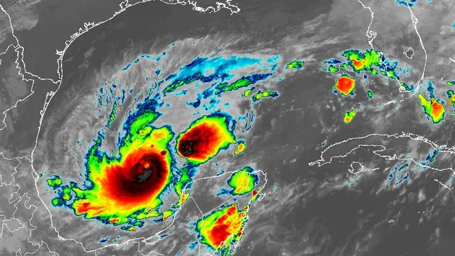
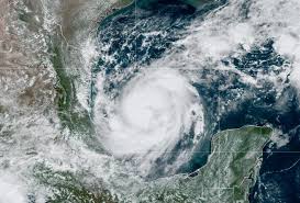
The situation’s urgency cannot be overstated as Hurricane Milton reaches Category 5 strength on its approach to Florida. The storm is expected to unleash a devastating surge along Florida’s west coast, including the Tampa Bay area. A slight decrease in strength is forecast ahead of landfall, but the potential for a catastrophic impact remains.
Milton, a top-tier Category 5 hurricane over the Gulf of Mexico, is intensifying at an unprecedented speed as it churns toward the west coast of Florida. According to the National Hurricane Center, the storm is expected to make landfall Wednesday or early Thursday as a “large and powerful hurricane. ” It is predicted to produce a potentially unprecedented ocean surge of over 10 feet in some areas, including perhaps in flood-prone Tampa Bay.
Since Sunday night, the storm’s rate of strengthening has reached extreme levels — its intensity leaping from Category 1 to 5. The storm’s peak winds Monday midday were up to 160 mph, a 70 mph increase in 12 hours.
The Hurricane Center described the storm’s rate of intensification as “remarkable.” The explosive development has occurred over record-warm waters in the Gulf, with the extreme warmth linked to human-caused climate change.
Milton is the strongest hurricane in the Gulf of Mexico since Michael in 2018 and is poised to become even stronger until a very gradual weakening trend commences Tuesday. It is the strongest Gulf of Mexico hurricane this late in the calendar year since at least 1966. Milton is one of only seven hurricanes on record to increase from Category 1 to 5 in 24 hours and did so at the second-fastest rate.
Only 48 to 60 hours remain before Milton arrives in Florida. Landfall now looks to be Wednesday afternoon or evening, and the storm—despite some weakening—is anticipated to remain a major hurricane with winds around 120 mph when it strikes the state’s west coast.
Moreover, Milton’s wind field will expand, meaning the storm will more efficiently pile water against the coastline. The National Hurricane Center is warning of a 5 to 10 feet surge along much of the Gulf Coast of Florida’s peninsula, with locally up to 8 to 12 feet—including in Tampa Bay.
Depending on Milton’s exact track, Tampa could find itself in the most dangerous part of the hurricane. The vulnerable coastal city could suffer billions of dollars in damage in a worst-case scenario track, which is a possible outcome. Some neighbourhoods would be entirely inundated and inaccessible. Ongoing evacuations are expected to be the most expansive in Florida since Hurricane Irma struck in 2017.
It’s important to note that subtle shifts of only 5 to 10 miles in track will significantly affect surge outcomes. While it’s impossible to outline who will see the worst surge, a devastating surge is virtually a certainty somewhere along Florida’s west coast.
A storm surge watch is in effect from the southern tip of the Everglades to the mouth of the Suwanee River in the Big Bend. A storm surge watch means there is a possibility of life-threatening inundation from rising water moving inland from the coastline in the indicated locations during the next 48 hours. That includes Tampa Bay and Charlotte Harbor — a region ravaged by Hurricane Ian in late September 2022.

In addition, Milton will bring destructive winds — perhaps gusting over 100 mph at the coastline — capable of uprooting trees, damaging buildings, and causing widespread power outages. The storm will also bring heavy, flooding rains, with some areas expected to receive several inches of rainfall quickly, leading to flash floods and potential landslides. There is also a risk of a few tornadoes, adding to the potential for widespread destruction. Hurricane watches span the southern part of Florida’s Big Bend, ravaged by Helene less than two weeks ago, to just south of Marco Island.
Widespread power outages are probable in Florida’s interior and even as far away as the state’s east coast. They could affect cities such as Orlando and Daytona Beach, as well as Tampa, Fort Myers, and Sarasota.
Late Monday morning, the storm was centred about 130 miles west-northwest of the northern tip of Mexico’s Yucatán Peninsula and 720 miles southwest of Tampa. It was headed east-southeast at 9 mph and is expected to turn northeast on Tuesday.
The storm also exhibited an ominous “enveloped eyewall lightning” signature on satellite. This is a rare and alarming phenomenon, as hurricanes only produce lightning when they’re strengthening, usually quickly. The entire eyewall, or innermost ring of ferocious winds, has been sparking hundreds of lightning strikes — a warning of a top-tier storm. The Hurricane Hunters even encountered hail when entering the eyewall from the northwest, indicating the storm’s extreme strength and potential for destruction.
Milton is expected to affect some of the same areas that experienced a destructive surge from Helene, representing a significant setback for recovery efforts. Parts of Florida’s west coast already saw a 5- to 7-foot storm surge and are removing debris and sand from Helene.
- Farah Khan का नया कैंपेन | बच्चों को एडल्ट स्किनकेयर क्यों? | Tuco Kids Campaign India
- महिलाओं को मिलेगी नई गति: ऑटो सेक्टर में प्रशिक्षण के माध्यम से आत्मनिर्भरता को बढ़ावा देंगे डालमिया भारत फाउंडेशन और रेड कार्पेट
- OYO ने शीर्ष होटल प्रबंधकों को सम्मानित किया, महाराष्ट्र में विस्तार को प्रोत्साहित किया
- Podmasters 2025: भारत के तेजी से बढ़ते पॉडकास्टिंग लैंडस्केप का उत्सव
- स्कोडा ऑटो इंडिया ने जयपुर में दो नए शोरूम शुरू किए, राजस्थान में टचपॉइंट्स की संख्या 14 हुई
